Modeling Water flow using DEM (Digital Elevation Models)
Water flow Analysis showing where micro Check dams can be located
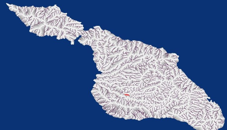
 Grey areas show where water can be captured using micro-check dams so every major storm will refill the reservoir.
- Dark lines represent large water flow areas were larger professionally engineered dams are needed and are likely riparian zones.
- White areas are those where this is insufficient water to refill the check dam every storm
- See Our Interactive Check Dam placement Maps Rodrigues Island Interactive Map
The analysis uses a set of water flow modeling rules with NASA SRTM DEM (Digital Elevation Models). It models where water will flow and how water will aggregate at certain points. We use that data to determine where micro check dams can be built to maximize infiltration. See Also Scala Code to Download and render DEM
The same water flow analysis could be used to identify risk points for floods under various storm scenarios.
Building many small dams on higher terrain avoids risking sensitive riparian habitat near creeks and rivers. It also captures a majority of soil reducing silt loads in downstream dams. By buffering the water flow we can reduce flooding, produce more consistent downstream river flows and recharge local aquifer.
This process creates many pockets with deep moisture where rich soil will collect to support plants and increase biodiversity. It is one of the cheapest ways to mitigate impact from deforestation and start re-establishing those forests. We are also working on easy to use devices to help collect the data needed to build 1 and 3 meter DEM grids to allow even more precise modeling.
[paypal-donation purpose=”Ease Water Scarcity” reference=”rain capture”] Support our Demonstration project on Rodrigues Island
Rodrigues Island Water flow
Rodrigues island in the India ocean is faces water scarcity even thought they receive quite a bit of rain. Rainfall has dropped in recent years but there is still sufficient water available if they can retain more of it for use rather than allowing most of it to run off into the ocean.
The grey shaded areas are where we have identified a possible location for a check dam. The scale is such that larger grey shaded areas may need dozens of check dams to maximize infiltration. Each check dam can retrain between 200 and 2500 gallons of water. Creates a deeply moist spot where trees can be grown and can be lined to provide liquid water.
Poor rural farmers on Rodrigues are faced with a double impact with vastly reduced production from their farms due to water scarcity coupled with increased prices for food and other supplies. This is an island that offers few other opportunities for income so loss of farm income can be devastating for poor families. We believe this problem can be largely fixed by by installing thousands of micro check dams can recharge their aquifer while creating many pockets of deep and damp soil that can support deep rooted trees that produce animal fodder even during their drought years.
Our intention is to make the software freely accessible via web and smart phone to poor farmers suffering from water scarcity. We need your help to deliver the software and help train farmers in how to use it to dramatically improve their food production capacity during drought conditions. Ultimately we hope to see it reduce drought related famine around the world.
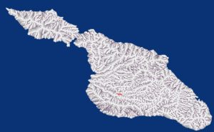
Rodrigues Island proposed dam placement
 Click on the image to to see full high res. Each purple dot is proposed location of a dam for a potential reservoir that would receive 133,000 gallons of water during each storm that generates more than 7mm (0.3 inch) of runoff. There are many storms this large even during drought years. The system identified 4,320 dams of this size. If there were all built they would impound 500 million gallons of water per storm most of which would wind up soaking into local aquifer. These larger dams can be designed to allow feed water slowly into downstream dams helping to extend the storage capacity of those dams. We normally prefer smaller reservoirs that farmers can build on their own property but this is a viable choice and can be done in parallel with the smaller dams built on the actual farms.
Sample of the Geo Position for Dams on Rodrigues Island
dam lat=11.98153 lon=-72.01403 elev=31.0 damDrainCnt=80
dam lat=11.98153 lon=-71.90736 elev=72.0 damDrainCnt=81
dam lat=11.98153 lon=-71.82848 elev=137.0 damDrainCnt=99
dam lat=11.98181 lon=-71.98375 elev=40.0 damDrainCnt=102
dam lat=11.98181 lon=-71.94708 elev=51.0 damDrainCnt=119
dam lat=11.98181 lon=-71.89236 elev=75.0 damDrainCnt=133
dam lat=11.98181 lon=-71.85292 elev=87.0 damDrainCnt=137
dam lat=11.98181 lon=-71.84708 elev=95.0 damDrainCnt=82
dam lat=11.98181 lon=-71.84320 elev=92.0 damDrainCnt=83
dam lat=11.98208 lon=-72.00958 elev=31.0 damDrainCnt=159
dam lat=11.98208 lon=-71.99709 elev=37.0 damDrainCnt=101
dam lat=11.98208 lon=-71.91875 elev=63.0 damDrainCnt=91
dam lat=11.98208 lon=-71.88181 elev=75.0 damDrainCnt=84
dam lat=11.98236 lon=-72.05042 elev=22.0 damDrainCnt=100
dam lat=11.98236 lon=-71.93098 elev=55.0 damDrainCnt=138
dam lat=11.98264 lon=-72.02014 elev=28.0 damDrainCnt=99
dam lat=11.98264 lon=-71.97903 elev=44.0 damDrainCnt=111
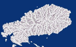
Catalina Island, CA Water flow model
Catalina island is a beautiful vacation spot but the hotels are always complaining about a very limited supply of water. Catalina is a perfect example of a island where we could install a few hundred thousand check dams to dramatically improve the water balance for the island. These dams will retain fertile soil and increase bio-diversity but the main benefit is that they can dramatically increase water recharge into their aquifer via infiltration.
Catalina receives 13 inches of rain average but they have 7 months where they receive more than 1/2″ of rain which is enough to recharge reservoirs. If we built 200,000 small check dams on the island each one retaining 1,500 gallons then each major storm would capture 300 million gallons while 7 major storms would capture 210 million gallons per year. Some of this water would be lost to evaporation but a majority of it would end up soaking and adding water to their fresh water lens. It is particularly important to maximize infiltration for islands that draw heavily on ground water because once salt water starts to intrude it is difficult and expensive to fix.
Catalina Island DEM
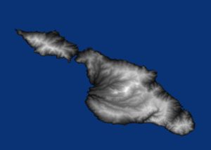
This rendering of Catalina island is made using SRTM1 data produced by NASA and downloaded from the USGS The rendering and shading logic is our own.
We rendered this so the highest elevations are the brightest while the lowest elevations are the darkest. You can generally assume that water will flow from the (brightest) highest areas to the lower areas (darker)
Cities and Water Table Recharge
The municipal water district of most major cities own or control access to the a portion of land considered essential to provide water for that city that they typically call watersheds or conservation districts. In many cases they build reservoirs to store storm water and hold it available for later use. When too many storms arrive too fast they are forced to let water they would have preferred to retain go down stream. Sometimes they are forced to release billions of gallons they will desperately need a few months latter.
Micro Check dam benefits for larger cities.
- Maximize the amount of water that falls in their watershed that is retained for future use.
- Soil erosion and silt load is greatly reduced extending the life and storage capacity of existing reservoirs.
- A very large amount of water can be captured and stored in local aquifer where it can be drawn from latter. At a far lower cost than building additional large reservoirs.
- Water currently lost to the ocean can be captured and used to recharge aquifer.
- Storing water in the aquifer is far less expensive than storing it in surface dams or tanks where they hydraulic is compatible.
- Water flow can be buffered so rather than hitting the storage dams all at once it arrives slowly over the period of weeks or months which gives the water planners time to make better decisions. Sometimes they are forced to release water for safety reasons even before they are sure how much water a storm will deliver. By slowing the arrival of the water it gives them time to make more informed decisions.
- micro check dams are smaller and cheaper with low impact.
- Low permitting overhead with less push-back from environmental groups.
- Great way to put idle labor to work at minimum wage building micro check dams rather than waiting for welfare.
Our Software can help cities locate all the places where they may be able to build check dams. Our ability to help them build 1 and 3 meter fine grained DEM can help them make even more precise location decisions.
Cities and controlling flood risk
China recently faced major floods caused by abnormally large rainfall. This threatened Beijing and other major cities. Killed over 100 people and displaced thousands with 53,000 homes destroyed. Similar floods have been faced by many cities in Texas including Austin. These cities share both represent billions of dollars of valuable developments built in a area where water scarcity limits food production and could result in food scarcity. It is a shame to see a valuable resource wasted.
Both cities are surrounded by massive tracts of land where rain can fall and the sheer volume of that land can make traditional flood control measures difficult and expensive. Austin along spent over a 100 million to buy homes in the onion creek area.
We propose an alternative approach where several hundred thousand check dams are build in upstream water sheds. These check-dams can be sized to capture the first 4 inches of rain or even more in extreme flood prone zones. They are designed such that water will slowly filter through the dams in over a period of several days to several weeks but a good portion of the water will soak in.
Analysis from our software can help cities find all the locations where micro-check dams will be viable. Some sites may not be viable due to prior land use but we will be able to find more sites than they need to control the flood risk.
Flood reduction from micro check dams :
- Dramatically reduce the amount of water available during peak flood events.
- Reduce peak flood levels which can reduce property damage.
- Produce thousands of pockets of greenery that can support grazing and wildlife.
- Stores a large fraction of water from storm events in local aquifer.
- Capture most of the silt and other debris that normally contributes dangerous conditions during peak flood events.
- Produces nice pockets of enriched soil that is also deeply moist and can support new trees and wildlife.
- Adds billions of gallons per storm into local aquifer through infiltration to boost supply for those drawing from ground water.
- Gives the downstream reservoirs time to cope with the water and make more informed release decisions.
- Easy and inexpensive to build micro check dams have minimal impact.
- Small micro reservoirs pose little risk even if they do fail.
- Far less permitting and environmental push-back compared to major reservoirs used to accomplish the same task.
- Ideal way to put idle labor pools to work at minimum wage building check dams rather than waiting to receive welfare.
Possible Industrial Use DEM water flow Analysis
Companies like Shell have to be very aware of where water flows from and where it will flow to. If they do not have this understanding they can be surprised when a major storm over fills settling ponds causing them to spill dangerous or regulated chemicals into downstream rivers.
This analysis can be used to locate check dams and diversion dams so the water flow even during the most extreme storms never reaches their facility.
Using micro check dams like these can maximize aquifer recharge via infiltration which means ore water can be made available to support their activities especially when they are drawing water from rechargeable aquifer. Companies like shell may be able to negotiate environmental remediation credits from these dams to help offset other project impacts.
Benefits for industrial users:
- Gauge exact risk from different upstream storm events.
- Maximize infiltration precipitation to recharge aquifer thereby maximizing water available for extraction.
- Reduce complaints of excess water usage from surrounding citizens.
- Minimize risk of settling or containment ponds being breached under exceptional weather events.
- Provide a large source of water at a relatively low cost especially in areas where they can buy land on hills outside of cities.
Our software can help business owners and land developers accurately gauge their risk from flooding of land uphill. It can also help them select parcels ideally suited to capture water they can then redirect for the use of their business (where water rights allow it).
admin • 2016-11-17