Improve Economic Prospects for Poor Rural Farmers
Small village farmers on Mauritius and Rodrigues Islands have been forced by water scarcity to reduce the amount of land they can cultivate by 2/3 In some instances they have been forced to purchase expensive water from retailers bringing it around on carts. This has reduced their farm income and pushes them closer to poverty. This is on an island that receives over 373 mm of rain even during drought.
See Our Interactive Check Dam placement Maps Rodrigues Island Interactive Map
 Our approach is to retain water that falls during storms, give more time for the water to replenish underground aquifers and provide water to help farmers grow vegetables during the dry season. It also supports reforestation with deep moist pockets of fertile soil.
Water scarcity on Rodrigues island water scarcity can be solved quickly using properly located check dams. While we use Rodrigues island as a example the solution can be applied across water scarcity regions in Africa, Asia and the middle East. Support our Rodrigues Island project on Go Fund
Many farmers have 3 to 6 acres but they can only farm a small portion of it due to reduced water supply. This can reduce their income below survivability and make it unprofitable to farm.
Imagine each of these small farmers being able to grow enough addition food to support 45 goats or sheep without needing any ground water or depending on water delivered by the government. Now imagine they can do this even during drought.
This could profoundly improve their lives by delivering income equivalent to over 300 days of day labor. (Calcs below)
This can be accomplished even during drought by building 65 check dams per acre on their existing soil where each dam captures about 250 gallons of water per storm. Each Check dam creates a pocket of deeply moist soil can be used to grow deep rooted trees that produce edible fodder. A 4 acre parcel can produce 50,000 pounds of edible fodder which is enough to support 45 animals even if they have no other food source.
In many cases check dams have historically been built in ravines. Our approach moves the check Dams out of the ravines up onto hillsides as close to where the rain falls as possible. This allows small, inexpensive check dams to be built while
Locating Check Dams
We need at least some slope when installing check dams. A complex topography of compound slopes works best because it provides many funnel points where we can build small check dams. Most land has sufficient slope even it it appears flat but truly flat land requires a different approach.
To maximize the number of points where new fodder can be grown we want to maximize the number of check dams that can be installed on each farmers property. This means we want each check dam to be placed so it will receive the targeted amount of water from each rainstorm.
We are working on software and data collection hardware that can use digital elevation data to tell you exactly where to place your check dams. You would spend a few days gathering data by walking from point to point so the precision GPS elevation system can measure elevation. Our software then uses the elevation data to predicts where the water will run and can tell you where to build your check dams.
Contact us if you can help fund building the techlogy to make locating check dams easy
or
We also need funding to make loaner versions of the data collection kit available to poor rural farmers.
Manual Check dam location process:
- Find the high points on the land.
- From there we compute how much water will be available from a given storm.
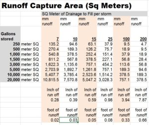
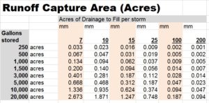
- Compute how much land will be needed to fill reservoir target such as 250 gallons. See chart below.
- Figure out where the water will drain from the high points based on water running down hill towards lower land.
- Find the closest low point relative to the the nearest high point where there is sufficient land supplying enough runoff water fill the reservoir.
- We use sophisticated software for this but the manual version essentially involves making a map of all your measured elevations for your property using a 1 meter grid. Find the high points on the land can color them green. Divide the total elevation gain for the property by 24. This gives you 24 unique colors for each unit of elevation gain. Then assign a color for each point of land based how far it is below the highest point. This will give something of a visual map you can use to see where water will flow. You can also use a smaller number of changes and gray scale so the land further down gets colored slightly darker with the land at the lowest point getting colored the darkest. I find the grey scale version works better to see the elevation and likely water paths. When you have a lot of elevation gain or small pieces of land that stand far above rest then it can be easier to model them separate from the rest or they act as statistical aberrations that mess up the visual model. We are working on equipment to gather the data using a pole and a GPS data gathering kit. We then use software to develop the water flow model making it much easier and much less work. We want to make this freely available to poor farmers around the world but need financial assistance to do so. if you can help then please contact us.
- Look around to find a relatively close spot that would allow a smaller check dam to collect the water.
- Build the check dam where it can capture the needed water using the least amount of rocks.
- Start the process over staring from the next high point or considering the bottom of the last check dam moving downward.
On Mauritius the larger storms will fill the all the reservoirs and still produce runoff. This means farmers should allow for the runoff from one check dam to fill the next.
Do not build the check dams in riparian zones at the bottom of rivers and creeks. These are considered ecologically sensitive and you will probably need special permits to build anything in these zones. Our check dams will be built on land that is normally dry.
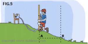 Egyptian Water Level: Measuring changes in elevation that may only be a few inches can be challenging but luckily the Egyptians invented the Egyptian water level to solve this problem. This device makes it quite easy to measure changes in elevation as small as 1/4″ using a bucket full of water, A clear flexible tube and a ruler. The tube is connected to the bottom of the bucket on one end and the other end is taped up the side of a ruler. The water going up the ruler will always stabilize at the same level as the water in the bucket. If the water rises in the tube then that land is lower. If the water falls in the tube the land is higher. You can measure how much lower or higher by how many inches the water moves. After you move the ruler the water will oscillate a bit when moving spot to spot so wait for it to stop moving before you take your measurement.
Land size required for collecting sufficient runoff to fill a reservoir from a single storm.
Whenever the soil is dry some portion of the rain will soak into the ground before it generates any runoff. You need to know for your area what this number is because it needs to be deducted from the rain that falls before you can compute runoff. A general rule is the first 0.2 inch of rain will be soaked in but this can be higher in loamy and sandy soils. Some desert soils may absorb very little due to a desert crust.
The general goal is to fill the reservoir from each storm. In many areas it is better to size the reservoir for the amount of rain dropped by the average storm during the dry season since that is when retaining water is most critical. In areas with strong monsoons but very long dry seasons where very little rain falls it is better to size the reservoirs larger so they can hold more water as they exit the monsoon season.
This sizing and location process done manually can be daunting. We are building tools to make it easy to accomplish using smart phones and web pages. Contact us if you can help fund building the techlogy to make the location and sizing process easy. We also need funds to assist in the first several test deployments so we can make sure the work as intended.
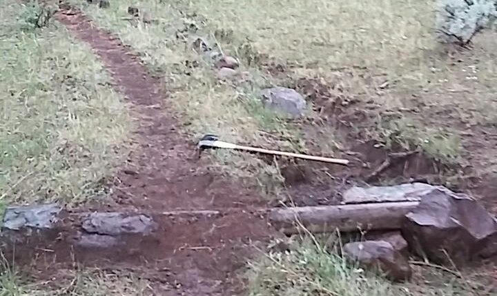
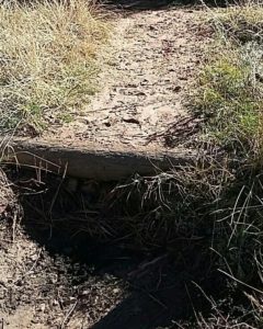
Building a Basic Check Dam
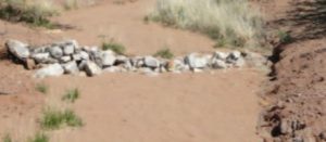
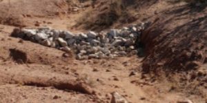 We intentionally keep our check dams small under 3 foot in height so they do not require significant engineering. Your goal is to impound the water to maximize soil absorption. Many approaches can work from the finely crafted stone retainer wall to simple rubble filled piles and in some instances a handy log can work. Take a look at the pictures in High Sierra Check dams before you build your own.
Size of water behind a dam assuming the reservoir is either 1.5 or 3 foot deep
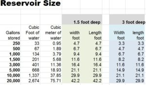
Water weighs 8.24 pounds per gallon. A 500 gallon reservoir of water will weigh 4,170 pounds. Most of this weight is simply pushing down on the ground but a portion of it will be pushing against your dam. If your dam is not heavy enough the water will push it out of the way.
Process for building a basic Check Dam
Check dams can be considered semi-porous or water tight. When we are using them to maximize water absorption and we may have long periods of time between storms, minimizing leakage through the dam preferable. This process describes building a mostly water tight dam where nearly all the water is retained behind the dam until there is sufficient water to flow over the top.
- Dig out a 6″ grove from surface dirt across the breadth of dam. Optional.
- Place a layer of biggest rocks available that you can easily move across the dammed area.
- Place a layer of the next smaller rocks on top of the first layer.
- If you do not have variable sized rocks large enough to matter then just create a rubble heap sloping down on both sides. See the surface strengthening section below.
- Continue building until you reach desired height. Make sure the top of the dam where it meets the surrounding soil is several inches higher than the spillway. Otherwise water will eat the soil out and bypass the dam.
- Fill in rocks on the uphill side until you have a nicely staple slope from top to bottom. The angle depends on how tightly you packed the rocks and weight of water pushing against the dam but 30 degrees is a good start.
- Using a shallow slope from top to bottom increases time cost because it requires more rocks but a shallow slope allows the water above the slope to push down which helps hold the dam in place. In addition it increases the weight of the material holding the dam in place which will reduce the risk of water pushing the dam out of the way. These are small dams so it is general better to build as fast and cheap as reasonable.
- On the uphill side Fill in all the areas between rocks with dirt, sand clay sand and pack as tight as possible.
- Choose a spillway or over-topping area where excess water will flow over the top of the dam. This must be a few inches below the rest of the dam.
- If you want maximum water retention then layer a sheet of plastic like painters tarp over the dirt. Alternatives are clay or even dirt mixed 10 to 1 with cement. This is considered the water proofing layer.
- Cover the waterproofing layer with a layer of packed dirt or sand then cover that with small rocks. Remember animals will walk on this and you don’t want their hooves to puncture the waterproofing layer. The more diligence you apply here the lest maintenance work you will do latter. The better job you do with water proofing the more water you will retain in your dam.
- Optional extend your water proofing layer to include the first several foot land on the uphill side of the reservoir. The larger area you cover with this slower the water will soak into the ground. This will preserve more water to build for animals and to use for vegetables.
- If you want to grow rice in the flooded reservoir then use clay to cover the entire bottom of your your reservoir it doesn’t have to be high purity clay so it can be dug out of any natural source you can find.
- Figure out where you want water to drain out of the check dam an ensure that area is covered with small rocks to minimize erosion. You also want to use some rocks at the bottom to help spread the water out when it drains so it doesn’t create a huge rut. The more diligence you apply here the lest maintenance work you will do latter.
- Pile rocks on the down hill side sloping from down and out from the top. This extra weight can help hold the dam in place during huge storms. The better you do here the longer the dam will last.
Correct Sizing a Check DAM: Building check dams too small can result in DAM failure. Building them too big and heavy is safer but drives up costs. The best approach is to make the dam heavy enough without wasting time and materials.
Dam Sizing can be difficult to compute unless you are a hydraulic expert. We are working of software that makes it easy for farmers to compute the size of check dams based on the material they have to work with, dam style, area dammed and amount and height of water stored. Our goal is to make service this freely available on phones and web pages. If you can help fund building and delivering this technlogy then please contact us. The cost is low while humanitarian benefit can be immense.
Strengthening the surface of the dam: It is not recommended to build the entire dam using only dirt fill without rocks because water running over the top will erode the dam away. If you are forced to use only dirt because rocks are not available then consider capping the dam with 2 inches of soil where you have mixed 10 parts soil with 1 part Portland cement (by volume) and then packing it tight. In the spill way use a 1 inch thick layer with 1 part cement per 5 parts soil and ensure all your excess water will flow through this section. It is preferable but not essential to mix the soil and cement wet but do try to mist the soil mixed with cement several times as it is applied and packed so it has enough water available to start the setting process. We have also found that a mixture of cement, lime and vermiculite works well with multiple layers of burlap to make a very strong thin cement layer.
Keeping more water for animals to drink: : The basic check dam is designed to allow maximum water to absorb into the soil beneath the reservoir. In some instances it is desirable to retain more liquid water in the reservoir pool. When this is desired then the waterproof layer used in the DAM is used to cover the entire bottom of the reservoir. Since we know animals will stand in the reservoir it the waterproofing layer needs to be covered with sand, soil or rocks to protect it from their hooves.
Computing the ROI for the Farmer
It is important to remember that the land used for run-off can continue to be used for grazing or other purposes. We do consume a little area for the dams and reservoirs but most of the land will remain untouched. As such the existing economic production from that land will continue or increase due to increased water availability.
For Mauritius island using 15 mm of runoff per storm is fairly conservative. Using the chart above we know that we need 0.016 acres of land to gather 250 gallons of water per storm. This allows the farmer to build 62 reservoirs per acre where the topography cooperates. During each storm the 5′ X 5′ reservoir will be filled with 1.5 foot of water and will soak into the soil below the reservoir.
On Mauritius we can expect 10 storms a year delivering at lest this much water so in each 5′ X 5′ reservoir the dirt below that area will absorb 2500 gallons of water per year. This works out to 155,000 gallons per acre or 620,000 gallons for the 4 acres. For each of these 5’X5′ sections of land this works out to 15 foot of water per year that will either soak, get consumed by plants or animals or evaporate.
The 5′ x 5′ reservoirs are the right size to grow one larger deep rooted tree or a number of deep rooted bushes that goats and sheep can eat. We can expect the combined edible fodder from a larger adult tree to deliver 200 pounds of edible fodder. In addition there will be wood trimmings that can be burned for fuel and once every 15 years they can harvest the trees for lumber. We normally prefer the Albizia Lebbeck because it’s leafs are high in nitrogen and can be used to increase vegetable yield by 400% with the same water budget when composted and used a soil amendment. The Albizia Lebbeck can not tolerate flooded roots and check dams in Mauritius climate will deliver so much water that it may be easier to use a water loving tree that can grow as either a tree or a edible bush such as willow.
The Albizia Lebbeck tree could be grown near some of the dams on higher land provided it is planted at least 5 foot away from the water reservoir. By planting a ring of them you may be able support 10 trees per reservoir which would increase fodder yield to 2,000 pounds per reservoir.
For a small farmer with 4 acres this would yield 4 acres * 62 deep moisture pockets * 200 pounds of additional fodder per pocket = 50,000 pounds of additional fodder. A goat requires about 3 pounds of food per day so they could support 46 additional animals. If these animals sell for $135 USD each this makes their value about $6,210. On an island where the daily labor rate is $20 USD per day outside the port region this represents about 310 days of income.
In reality the number of animals that could be supported could be larger because there will be some grass growing in the shade of these trees. In addition the excess leaves can be harvested, composted and turned into nitrogen rich fertilizer that will reduce the amount of water required to grow vegetables or increase the yield using the same amount of water and land.
The value computed above did not include the value from vegetables that can be grown around the the larger reservoirs. We will add this value when we obtain sufficient data to compute that value.
Dam construction costs
We will assume the farmer building check dams has a local source of rock, sand, dirt and clay or they can excavate those from their own property. Assuming the materials are present then they should be able to build small check dams in less than 1 day. For more level parcels that require longer days. Assuming the farmer’s time on Rodriguez Island is valued at $10 USD per day and they do most of the work on their own then their labor cost for per reservoir should be about $10.00. Since we know they need to build a total of 248 check dams on 4 acres their property will have a labor cost of about $2,480. If we use the $20 per day labor rate then their cost will be closer to $4,960. If they can not find clay to seal their dam they may need to use plastic similar to painters drop cloth which should cost under $4.00 per dam so it could add $992 to the cost. This would bring the high end cost to about $5,952. These numbers would obviously be different in markets where the labor rates are different.
Net ROI 18X Return over 20 years.
We computed above that the increased value of animals produced on the land would average $6,210 per year. We know now the high end of costs would likely be $5,952. This would seem to imply 1 year payback but it will take time for the trees to grow and during that time they will have to add animals slowly. They should be able to reach nearly the full carry capacity within 5 years depending on the trees they choose. It may be better to model it assuming they only make $2,000 in value per year for the first 3 years which grows rapidly after that. We can expect the check dams to continue delivering their benefits for at least 20 years with minimal maintenance. We will use the formula of (3 * 2000) + (17 * 6,000) to yield a 20 year value of $108,000 USD. This would make the return on investment 108,000 / 5952 = 18.14.
The farmer will make a 18X return on their investment and most of that investment is in labor they can invest during their down time.
These numbers do not include:
- The value of vegetables and other edibles they can grow due to increased availability of water.
- Increased value from of the animals over the 20 year period.
- Value of lumber from 248 mature trees that can be harvested at least once during the 20 year time frame.
- Value of hand crafted furniture and cabinetry they can fabricate using the high quality timber.
Computing potential costs and ROI is relatively complex and has many dependencies on cost of local materials, value of labor, whether the labor is in-kind where they would work on the farm anyway or is something they must borrow money to fund. It also depends on what other options they have for income. How much water will be available in the future and what the value of their food and animals will be in their local markets. We are working on software to help farmers model this for their farm using their local values. If you can help fund building and delivering this technlogy then please contact us:
These numbers depend on a series of well founded assumptions but some could be wrong so the values could be higher or lower depending on what we find needs to be change.
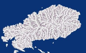
Drainage Analysis Rodrigues island
Check Dam analysis from Rodrigues Island in the India Ocean uses NASA SRTM1 data to project water flow during storm events. Using this we can determine where check dams would capture the correct amount of water.
- Grey shaded zones are those where the system has recognized sufficient water accumulation from a single storm to build check dams.
- Darker lines represent locations where too much water will already gather and would likely require larger professionally engineered structure.
- White lines are those where there is not sufficient accumulation to make a check dam worthwhile.
The next step is generating specific lat/lon coordinates as candidates for check dams. Part of the project includes building localized 3 meter DEM grids to allow more precision location of DAMs that can use less material. See https://www.gofundme.com/ease-water-scarcity-on-rodrigues
Questions we need Confirmed Answers:
- Number of people with reduced farm income due to water scarcity? % would also help.
- Number of people suffering reduced access to potable water? % would also help.
- Size of average family farm on Rodriguez in acres? On Mauritius?
- What portion can they not cultivate due to lack of water? Average for those affected?
- Average Annual income for those living from farm income?
- Portion or Amount of farm income is lost due to lack of water?
- Daily labor value for those living from farm income? Or Annual farm related Income?
- Alternative places they can sell their labor?
- Value of a Goat or Sheep sold live in current market?
- What portion of affected families are only making a portion of their income from farm? How does water scarcity affect net disposable income?
- How does this affect their food security? Are they going hungry?
- What is governments current plan to solve the problem?
- What is probable cost for the solution? By family?
- What is combined estimated lost income for farm production due to water scarcity.
- What is combined estimated financial impact for limited access to potable water.
Mauritius links
- Rural Poverty in Mauritius
- Mauritius Statistics
- Mauritius – System Country Diagnostic World Bank Group
- State of worlds animal genetic resources country report for Mauritius
- Rainwater Harvesting in Small Isolated Islands The island of Rodrigues is characterized by a highly rugged relief and very steep slopes, which resulted in the absence of naturally impounding reservoirs, and rivulets which flows very rapidly to the sea. Most of the surface runoff which arises during the wet season is lost to the sea.
- Collapse and recovery in remote small island – A tale of adaptive cycles or downward spirals. Considers the small semi-autonomous island of Rodrigues (Indian Ocean). Looking at failure causes and how the island can become stuck in post collapse mentality.
- Water and Agriculture Facing Water Scarcity and Environmental Challenges Water is becoming increasingly scarce worldwide. Aridity and droughts are the L. S. Pereira. “Water and Agriculture: Facing Water Scarcity and Environmental Challenges”. Agricultural Engineering International: the CIGR Journal of Scientific Research and Development. Invited Overview Paper. Vol. VII. February 2005. 2 natural causes for scarcity. More recently, man-made desertification and water shortages are aggravating the natural scarcity while population is growing and the demand for water faces an increased competition among water user sectors and regions.
What About mosquitoes and standing water
This is obviously a concern especially in warm regions where mosquitoes breed. The easiest answer is to size the reservoirs and pools such that the water soaks into the soil fast enough that the eggs laid in the pools do not have time to hatch before the water on the surface evaporates. It it takes over 10 days for larvae to develop so as long as the water has been absorbed within 10 days we don’t have a problem. This may require adjusting the reservoir surface area versus depth to allow complete absorption within 10 days. It could still be a problem during monsoon season but there is so much standing water during that time that controlling larvae in our reservoirs will be of limited value.
I personally prefer going the other way and growing mosquito eating fish such as bass, bluegill and catfish in the pools and then moving those fish to a single larger pool as the smaller reservoirs disappear. If those fish are edible then it adds one more profitable output from the system where the mosquitoes represent a free food supply. You would need a pretty robust fish like a catfish so it can stay in the ponds until they are nearly dry and withstand repeated netting and movement if the reservoirs are drying out. The Gambusia affinis is too small to make good eating but they eat lots of mosquito larvae. Some North American frog Tadpoles eat larvae. The red-eared slider turtle is a voracious predator for mosquito larvae. Care must be taken to prevent the fish from escaping because they can be invasive.
For the potable water reservoirs we could simply add a small ozone trickle to the water. If if runs for an hour a day with adequate stirring then it should kill any larva before they have time become adult mosquitoes. The same approach could work for the open pools but it would add cost for a solar panel, a small air pump and the ozone generator and possibly a circulation pump. It seems like a waste to spend that money when you can feed fish instead. The ozone provides an added benefit of killing many forms of algae but it can also harm tender plants so if using ozone the trees should be planted outside the pool but near enough for their roots to reach the damp earth below the pool.
One clever approach is to use a small pump with a 300 mesh filter to suck all the water from one pool moving it into another pool. Let the dirt in the source pool dry long enough to kill any larva then kill any larva that end up in your filter. Once the original pool has dried for a few days simply pump the water back and reverse the process. This can be pretty cheap with a 9 watt pump and a 15 watt solar panel. Many of these small pumps offer 4.5 meter head so they can move the water quite a distance but it would be easier for the farmer if automated. Otherwise they would have to manually pump out 228 pools once every 10 days. It seems easier to grow fish or other mosquito predators.
Dryland Agriculture and Micro Capture
- Assessment of effect of recharge from a check dam as method of managed aquifer recharge by hydro-geological investigationsPaid Article – Evaluate the efficacy of a check dam constructed as a MAR initiative across Arani River, North of Chennai, India. About 63 % of water stored in the check dam resulted in groundwater recharge. This has led to an increase in groundwater level from 1 to 3.5 m until a distance of about 2 km. Nice set of reference links.
- Chec-Dam system in gullies – the most effective measure to conserve soil and water in chinese Loess Plateau The amount of sediment retained by check-dam systems is large and still trending upwards. Have supported high-yield croplands or orchards, enriching fertile soil and providing ample. The check-dam is the most important well-known project to conserve water and soil and the ultimate line of defense in the comprehensive control system.
- Effect of Check dams on runoff, sediment yield and retention on small semiarid watersheds Check dams have been shown to be an effective sedimentation mitigation technique. A 4.5-fold reduction of sediment yield from downstream watershed after installing 400 check dams. Increased vegetation diversity with creation of new habitats were also created by the check dams.
- Rainwater harvesting for Drylands and beyond
- A Brief History of Southwest Border Water Includes Anasazi use of check dams
- The Ancient Pueblo (The Anasazi)
- Semiarid watershed response to low-tech porous rock check dams USDA article Southwest watershed Research. The primary impact of the check dams was retention of channel sediment.
- Ancient Agricultural Systems in Dry Regions Anasazi constructed low stone check dams from 3 to 60 in a single channel. Providing stair step garden plots in series. The dams average 5 meter long and 1/2 meter high. There are more than 900 such dams on Chapin Mesa alone.
- Combating desertification with indigenous agricultural technlogy at Zuni Pueblo, New Mexico Runoff agriculture refers to methods of collecting and spreading ephemeral storm-water for crop use after each runoff-generating event. The techniques traditionally used in the Southwestern U.S. focus on diversion and spreading of concentrated ephemeral flows with combinations of brush weirs and stone check dams (Nabhan, 1984). Runoff agriculture dates back more than one thousand years in arid regions such as the Middle East (Evenari et al., 1982)
- HYDROLOGIC RESPONSE OF STREAMS RESTORED WITH CHECK DAMS IN THE CHIRICAHUA MOUNTAINS, ARIZONA Even 30 years after installation, most of the check dams were still functional. The watershed treated with check dams has a lower runoff response to precipitation compared with the untreated, most notably in measurements of peak flow. Concerns that downstream flows would be reduced in the treated watershed, due to storage of water behind upstream check dams, were not realized; instead, flow volumes were actually higher overall in the treated stream, even though peak flows were dampened. We surmise that check dams are a useful management tool for reducing flow velocities associated with erosion and degradation and posit they can increase base-flow in arid-lands
- Water, climate change, and sustainability in the southwest
- Check Dams at Chimney Rock Mesa: Agricultural Strategies in a Marginal Environment Paid Access – Check dam localities maximize runoff moisture and solar radiation in an otherwise cool, arid environment. In addition, it is argued that the Chimney Rock Anasazi exploited such productive micro environments to make agriculture a viable strategy in seemingly marginal environments.
- The Use of Check Dams for Protecting Downstream Agricultural Lands in the Prehistoric Southwest: A Contextual Analysis Paid Access – check dams in at least one locale served to protect large fertile tracts of downstream land from periodic inundation and influxes of poor-quality sediment.
- Growing Food in the Southwest Mountains (4th Edition): A Guide to HighCheck Dams known as gabions heal eroded dry washes. They are smal semi-permeable rock dams. Slows the water down allowing water to soad in more gently. Several dams along the wash are constructed to heal it completely. Shows a interesting design of rocks held together with metal fence. Looks nice but would be more expensive.
- High Sierra Check Dam Legacy a photogrpahic journal. Lots of great pictures.
- The use of check dams for protecting down stream agricultural lands in Prehistoric southwests a contextual analysis Paid Access
Related articles on this site
- Micro Capture to Increase Food Production in Dryland areas
- Reduce Soil Erosion & Rivers lost to Deforestation
- Groundwater recharge using monsoon water redirection
- Farmer Suicide driven by accumulated debt from failed crops and drought
- Grow Dryland to reverse desertification
- …
- …
- …
- …
Your Author: Joseph Ellsworth he is a trained enterprise architect who has been working on water scarcity, water provisioning and how water relates to water poverty for over 12 years. He has invented patented technlogy that helps solve the problem and passionately believes that Women and Children anywhere in the world should never need to walk more than a few hundred feet to obtain safe water.
Water scarcity and poverty are closely linked. In many cases it is poverty and lack of education that drives the water shortage. It is a thorny problem because people can not think about how to escape poverty when they are tired from struggling to obtain adequate water to survive for the next day or worrying about how to buy food the next day. It is made more complex in areas where desertification, soil degradation and changing rainfall patterns are making less agricultural water available and poor farmers trying to use traditional approaches while depending on rain for their water supply end up with repeated failed crops from drought driving them deeper into debt and poverty.This means you must solve both the problem of increasing profit from small family farms suffering from reduced productivity and shrinking water access to solve the core poverty problem while also solving the access to potable water problems. If you only solve the potable water problem without helping break the poverty cycle the potable water problem will re-emerge.
We believe this check dam approach can help solve both problems by increasing crop yield and providing an easy way to ensure adequate potable water. It can deliver these benefits even even during drought and it can break the escalating debt problem caused by repeated drought induced crop failures. We can not do this alone. If you can help fund developing and delivering the technology needed to make it easy for poor farmers to implement the Check Dam process on their farms then please contact us. We want to run multiple demonstration projects proving the concept can deliver the benefits promised but need financial assistance from philanthropists. Please contact us if you can help!
Thanks for reading
Joseph Ellsworth
CTO of Air Solar Water
![]()
![]()
Water Scarcity Related Articles
- Climate change water stress conflict and migration
- Risk livelihoods SEI Dow Wate Migration 2005
- Beyond conflict water stress contributed europe migration crisis
- Cost of water shortage: civil unrest, mass migration and economic collapse from the gaurdian Shell, Coca-Cola, Procter & Gamble, Cargill and other companies which depend heavily on secure water supplies
- Water scarcity risks being a source of conflict
- Climate Change & Migration and Water Shortage
- Water scarcity migration regional security south asia
- Climate driven water scarcity could hit economic growth by up to 6 percent in some regions says world bank
- Water scarcity and climate change
- Mediterranean migrant arrivals 2016 deaths
- http://www.american.edu/cas/economics/ejournal/upload/Global_Majority_e_Journal_2-1_Marshall.pdf
- https://www.die-gdi.de/uploads/media/ELR_engl_07-09_03.pdf
- http://www.emeraldinsight.com/doi/abs/10.1108/S2040-7262%282013%290000013015
admin • 2016-11-09
Comments